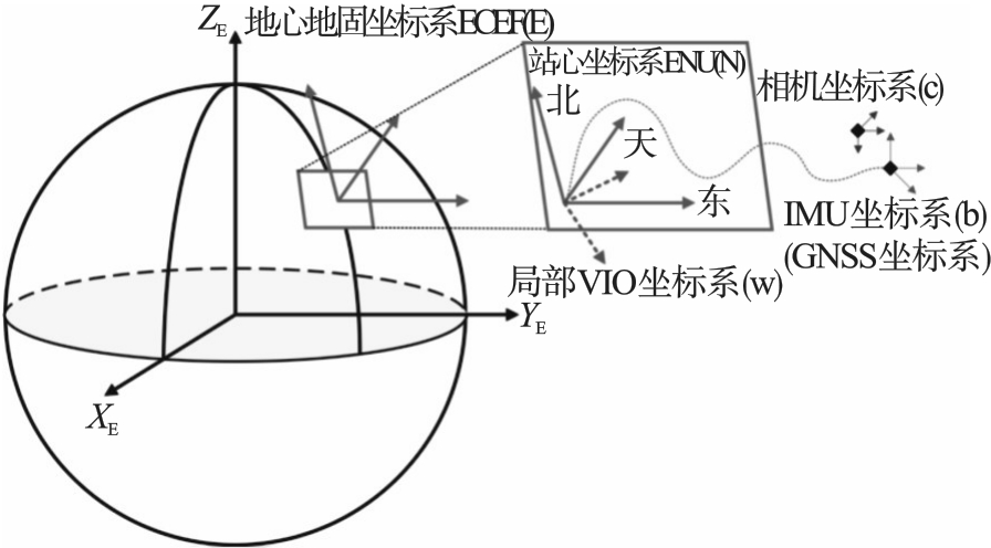
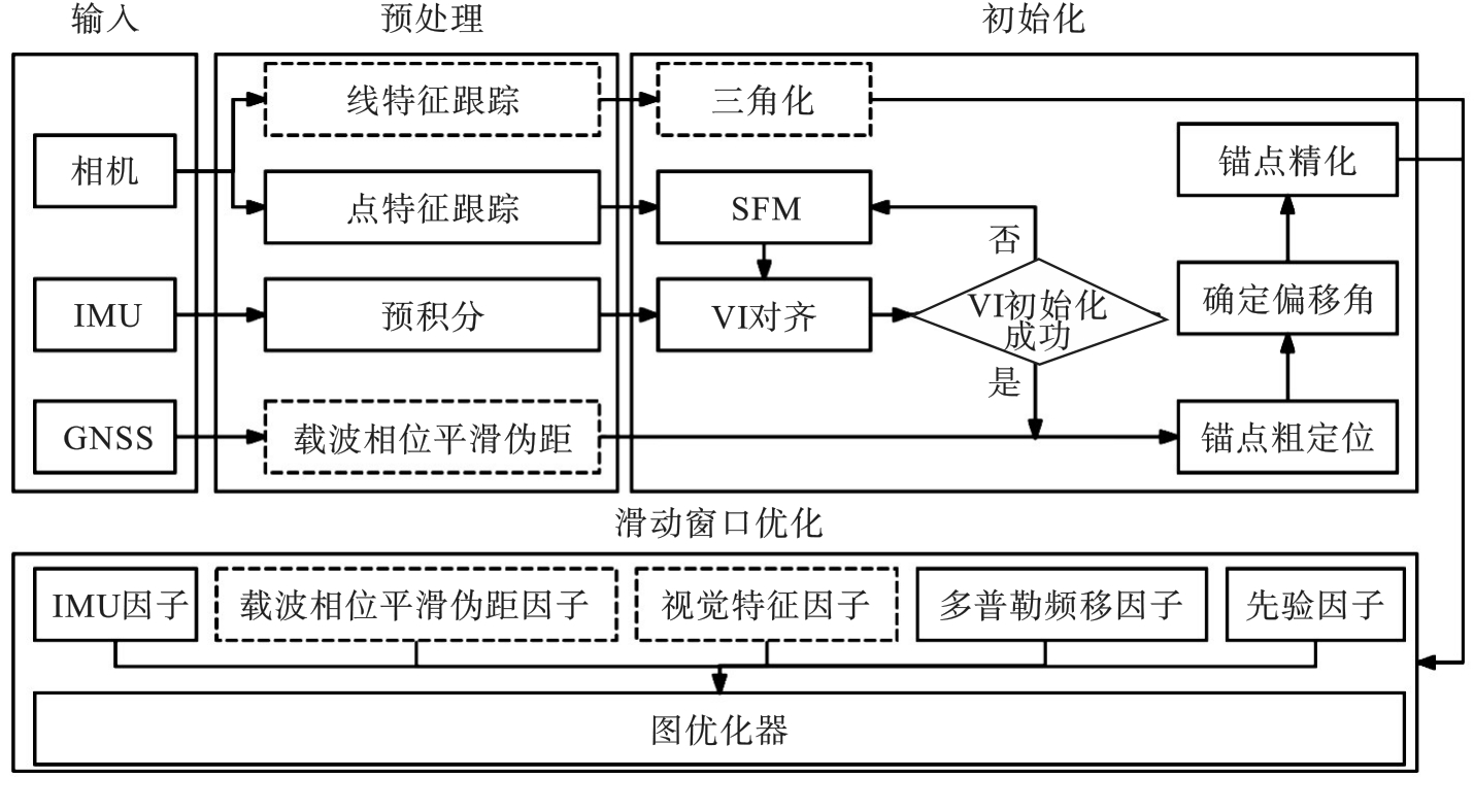
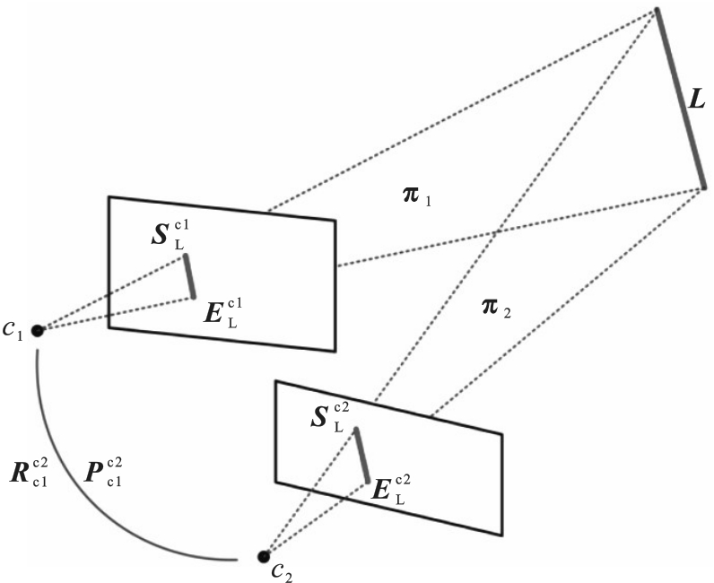
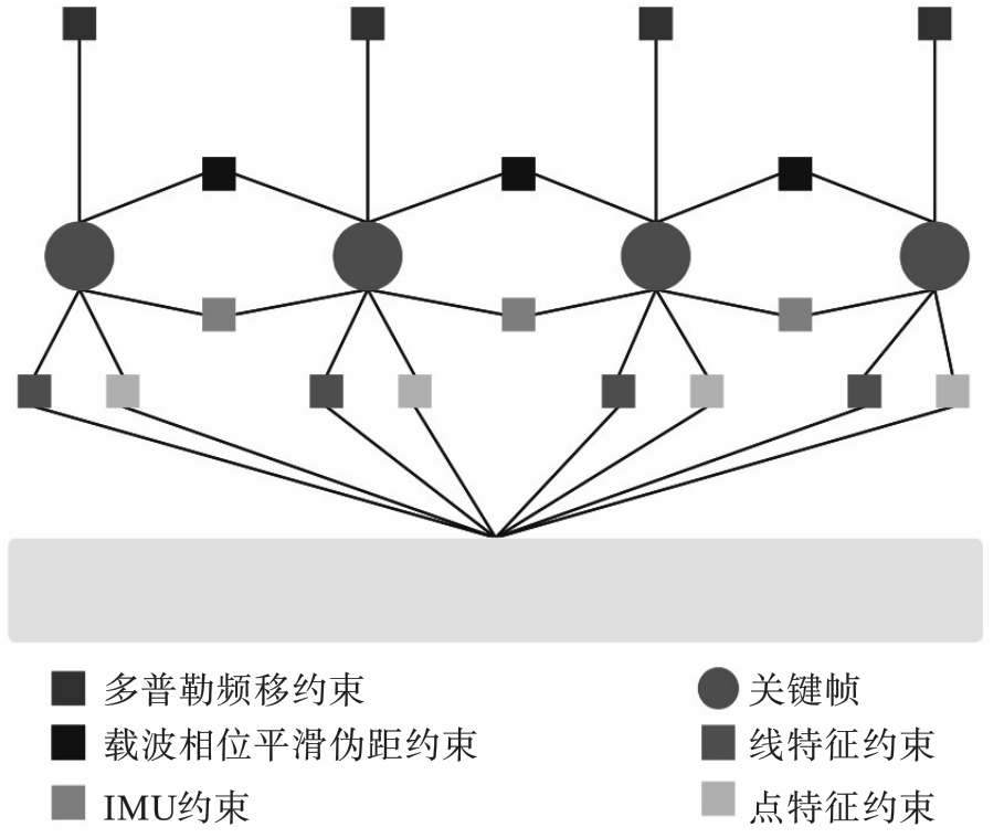
| 1 |
Davison A J, Reid I D, Molton N D, et al. MonoSLAM: real-time single camera SLAM[J]. IEEE Transactions on Pattern Analysis and Machine Intelligence, 2007, 29(6): 1052-1067.
|
| 2 |
Mur-Artal R, Montiel J M M, Tardós J D. ORB-SLAM: a versatile and accurate monocular SLAM system[J]. IEEE Transactions on Robotics, 2015, 31(5): 1147-1163.
|
| 3 |
Forster C, Pizzoli M, Scaramuzza D. SVO: fast semi-direct monocular visual odometry[C]// 2014 IEEE International Conference on Robotics and Automation (ICRA). Hong Kong, 2014: 15-22.
|
| 4 |
Engel J, Koltun V, Cremers D. Direct sparse odometry[J]. IEEE Transactions on Pattern Analysis and Machine Intelligence, 2018, 40(3): 611-625.
|
| 5 |
Engel J, Schöps T, Cremers D. LSD-SLAM: large-scale direct monocular SLAM[M]//Computer Vision-ECCV 2014. Cham: Springer International Publishing, 2014: 834-849.
|
| 6 |
王丹, 黄鲁, 李垚. 基于点线特征的单目视觉同时定位与地图构建算法[J]. 机器人, 2019, 41(3): 392-403.
|
|
Wang Dan, Huang Lu, Li Yao. A monocular visual SLAM algorithm based on point-line feature[J]. Robot, 2019, 41(3): 392-403.
|
| 7 |
He Y J, Zhao J, Guo Y, et al. PL-VIO: tightly-coupled monocular visual-inertial odometry using point and line features[J]. Sensors, 2018, 18(4): 1159.
|
| 8 |
Lee J, Park S Y. PLF-VINS: real-time monocular visual-inertial SLAM with point-line fusion and parallel-line fusion[J]. IEEE Robotics and Automation Letters, 2021, 6(4): 7033-7040.
|
| 9 |
Qin T, Li P L, Shen S J. VINS-mono: a robust and versatile monocular visual-inertial state estimator[J]. IEEE Transactions on Robotics, 2018, 34(4): 1004-1020.
|
| 10 |
Mourikis A I, Roumeliotis S I. A multi-state constraint Kalman filter for vision-aided inertial navigation[C]//Proceedings 2007 IEEE International Conference on Robotics and Automation. Rome, 2007: 3565-3572.
|
| 11 |
Sun K, Mohta K, Pfrommer B, et al. Robust stereo visual inertial odometry for fast autonomous flight[J]. IEEE Robotics and Automation Letters, 2018, 3(2): 965-972.
|
| 12 |
Campos C, Elvira R, Rodríguez J J G, et al. ORB-SLAM3: an accurate open-source library for visual, visual-inertial, and multimap SLAM[J]. IEEE Transactions on Robotics, 2021, 37(6): 1874-1890.
|
| 13 |
Mur-Artal R, Tardós J D. ORB-SLAM2: an open-source SLAM system for monocular, stereo, and RGB-D cameras[J]. IEEE Transactions on Robotics, 2017, 33(5): 1255-1262.
|
| 14 |
Langley R B. RTK GPS[J]. GPS World, 1998, 9(9):70-76.
|
| 15 |
Zumberge J F, Heflin M B, Jefferson D C, et al. Precise point positioning for the efficient and robust analysis of GPS data from large networks[J]. Journal of Geophysical Research—Solid Earth, 1997, 102: 5005-5017.
|
| 16 |
Xiang Y, Gao Y, Li Y. Reducing convergence time of precise point positioning with ionospheric constraints and receiver differential code bias modeling[J]. Journal of Geodesy, 2020, 94(1): 8.
|
| 17 |
Cao S Z, Lu X Y, Shen S J. GVINS: tightly coupled GNSS-visual-inertial fusion for smooth and consistent state estimation[J]. IEEE Transactions on Robotics, 2022, 38(4): 2004-2021.
|
| 18 |
林利蒙, 王梅. 改进点线特征的双目视觉SLAM算法[J]. 计算机测量与控制, 2019, 27(9): 156-162.
|
|
Lin Li-meng, Wang Mei. An improved stereo SLAM system through combination of points and line segments[J]. Computer Measurement & Control, 2019, 27(9): 156-162.
|